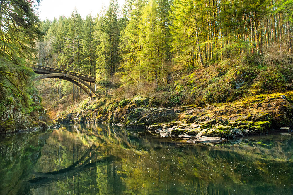
A THREE-STORY high arched bridge crosses the Lewis River at Moulton Falls Park, part of the Moulton Falls Loop.

A HIKE TO Silver Star Mountain is adorned in a riot of wildflowers during June and July.
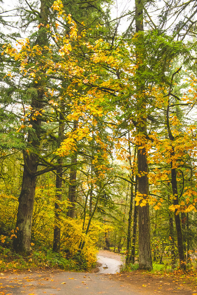
LEWISVILLE PARK is a scenic hike during any season, but especially in the autumn when trees are in a fiery show of golden color.


The warming days of spring and sunshine may be enticing you outside, but where do you go for some great fresh air and scenery?
It’s just a short jaunt to enjoy the bountiful parks and trails in our community. These are just a few of the hikes that are worth exploring in north Clark County.
Easy Hikes (up to 2 miles, little elevation change)
Battle Ground Lake – Lower Lake Trail
A one-mile dirt loop trail hugs the shoreline of Battle Ground Lake, with park benches strategically placed to pause and enjoy the scenery. Additional side trails offer a more strenuous climb up surrounding hills.
Battle Ground Lake is a crater lake, formed by water filling the ancient pit left following a volcanic eruption. The lake is stocked with rainbow and brook trout and is a popular fishing spot.
Admission is $10, or a $30 annual Discover Pass. There are seven upcoming days of free admission scheduled for 2015, including April 22, May 10, June 6, June 13, Aug. 25, Sept. 26, and Nov. 11.
Battle Ground Lake State Park is located at 18002 N.E. 249th St., Battle Ground, WA 98604, and is open from 6:30 a.m. to dusk in the summer, and from 8 a.m. to dusk in the winter. Phone (360) 687-4621 for additional information.
Ridgefield National Wildlife Refuge – Oaks to Wetlands Trail
The Oaks to Wetlands Trail loops for two miles through an estuary where, depending on the time of year, you may spot sandhill cranes, songbirds, migrating Canadian geese, swans, hawks, and more. It wanders through towering old growth Oregon White oak trees, and informational plaques identify native flora such as viburnum and oregon grape.
The 5,217-acre refuge lies along the shore of the Lower Columbia River and contains a mosaic of riverine floodplain habitat, seasonal and permanent wetlands, and agricultural lands.
The first section of the trail is ADA accessible, and leads to a scenic viewpoint with a nice vista of the refuge. Be sure to take a look at the historic Cathlapotle townsite and recreated plankhouse, which was visited by the Lewis and Clark expedition in 1806, and today is one of the best-preserved Native American sites in the Northwest United States.
Admission to the Refuge is $3, or an Interagency or Golden Age pass. Ridgefield National Wildlife Refuge is located at 1071 S. Hillhurst Rd., Ridgefield.
La Center Bottoms Hike
One of three designated National Watchable Wildlife sites in Washington, this 314-acre stewardship site consists of wetlands, floodplain shoreline, and forested uplands along the East Fork of the Lewis River.
La Center Bottoms is a 2.2-mile out and back trail which is mostly level and is a mix of asphalt, gravel, and mowed grass. Take a stroll to read the interpretive signs, and explore the wildlife blinds which offer camouflaged viewing areas to watch the animals – unnoticed – in their natural habitat.
No fee. From I-5, take exit 16 east to 319th Street, which turns into La Center Road. Just after entering town and passing the Welcome to La Center sign, turn right and park in front of the blue posts at the trailhead. Hours are 7 a.m. to dusk year round.
Medium Difficulty (2-4 miles, some elevation gain)
Lewisville Park Loop
Lewisville Park is Clark County’s oldest park, constructed by the Works Progress Administration during the Great Depression. Many of the park’s historic buildings date back to its founding in 1936. A three-mile trail system meanders along the East Fork of the Lewis River before climbing into nearby forested hills.
There is no fee. Take Lewisville Highway (state Hwy 503) two miles north from Battle Ground and park signs are on the right. Hours are 7 a.m. to dusk year round.
Moulton Falls Loop
The Moulton Falls Loop trail is about 1.7 miles, depending upon whether you explore side trails. It passes volcanic rock formations from early lava flows and a beautiful arch bridge over three stories high. The trail is heavily forested, and side trails from the loop provide up-close views of both Moulton Falls and Yacolt Falls.
Moulton Falls is the smallest of the five named waterfalls along the East Fork Lewis River, with a flume through a narrow trough, dropping over a series of potholes for about 10 vertical feet. The Chelatchie Prairie Railroad excursion train passes through this 387-acre park.
The park is located at 27781 N.E. Lucia Falls Road, Yacolt. The park is open 7am to dusk year round.
Lucia Falls to Moulton Falls Trail (Hantwick Road Trailhead)
A 2.5-mile (5 miles round trip) linear trail on the site of a former logging railroad, known as the Murphy Grade, runs from the Hantwick Road trailhead to Moulton Falls Park. The wide, hard-surfaced trail is mostly flat, making this an accessible year round hike. Along the way is a small wildlife-rich lake, rocky cliffs, and dense temperate rainforest.
There is No fee. From Battle Ground, take Highway 503N (Lewisville Highway) for 5.7 miles, then turn right onto NE Rock Creek Road, which becomes Lucia Falls Road. Drive 7.9 miles and make a right onto NE Hantwick Road. Go another 0.5 miles, crossing the East Fork Lewis River and then some railroad tracks before turning left into the Hantwick Road Trailhead parking area.
Whipple Creek County Park
Over five miles of trails loop through this 300-acre, heavily forested park, creating options for longer or shorter hikes. The stone wall ruins of a 100-year-old old dam and grist mill are one of the highlights of Whipple Creek, and efforts are underway to restore the original grist wheel, which is thought to be the only original wheel in the state.
This park is often used by equestrians; if you encounter horseback riders, keep everyone safe by stepping to the side of the trail and offering an audible greeting.
There is no fee. Park is located at 17202 N.W. 21st Ave., Ridgefield. The park is open 7 a.m. to dusk year round.
Longer
Silver Star Mountain
Open from May through September, the five-mile North Silver Star Mountain Loop offers extraordinary views of Mt. Saint Helens, Mt. Adams, Mt. Rainier, and Mt. Hood. During June and July, the mountains are blanketed in a rainbow of wildflowers.
A 1,700-foot elevation gain is not for the faint-hearted, but your efforts are well rewarded. The trail passes through a natural, key-hole shaped arch and climbs some steep improvised stone steps. From the saddle shaped double peak, you’ll have views of the aforementioned peaks, along with Mt Jefferson and the Three Sisters in Oregon, and the Olympic Mountains to the northwest in Washington.
There is no fee. From Battle Ground, drive 5.7 miles north on Hwy 503. Turn right on N.E. Rock Creek Road, which becomes Lucia Falls Road, and proceed 8.6 miles to Sunset Falls Road. Turn right and drive 7.4 miles to Sunset Campground. Turn right on gravel Forest Road 41 and cross a bridge to an unsigned junction where you go left. Proceed 3.5 miles (on unimproved road), turn right (downhill) on Road 4109 for 1.5 miles. At a multiway junction, turn left and go 2.7 miles to trailhead parking. High clearance and/or four wheel drive vehicles are strongly recommended.
Feeling ambitious? Some more difficult hikes in the area include Bells Mountain Trail, Tarbell Trail, Larch Mountain Trail, and the Lewis River Waterfall Hike. All right here in our beautiful backyard.