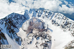
EARTH SCIENTISTS from several different universities and a handful of other institutions placed 3,500 seismological sensors and 23 seismic charges around the volcano for what they hope will be the equivalent of a volcano-sized ultrasound and CAT scan combination. File photo
This past weekend, 75 geophysicists were busy making Mount St. Helens rumble on command.
Earth scientists from Rice University, the University of Washington, the University of Texas at El Paso and a handful of other institutions placed 3,500 seismological sensors and 23 seismic charges around the volcano for what they hope will be the equivalent of a volcano sized ultrasound and CAT scan combination.
“Mount St. Helens and other volcanoes in the Cascade Range threaten urban centers from Vancouver to Portland, and we’d like to better understand their inner workings in order to better predict when they may erupt and how severe those eruptions are likely to be,” said Alan Levander, of Rice University, the experiment’s lead scientist.
The scientists are trying to get a better idea of the volcano’s plumbing system. The charges were placed deep below the surface and were detonated the evening of July 22 through July 23. The charges were expected to produce vibrations similar to a magnitude 2 earthquake. The blasts weren’t expected to be felt above ground, but the waves they produced through the landscape will give scientists an image of what lies below the surface.
Numerous volunteers set up the sensors, which are capable of reading very subtle vibrations.
“These sensors are basically a computer in a can with a small battery,” Levander said. “They’re about the size of a water bottle, but because of their limited power supply, we only have about two days to deploy the whole lot.”
Once the sensors are collected, the information should be available within a matter of days. Then, a smaller version of the process will happen on July 30 on different parts of the mountain.
The tests are part of a larger project called Imaging Magma Under St. Helens (iMUSH), which researchers hope will bring improvements in volcanic monitoring and advance warning systems at Mount St. Helens and other active volcanos.
The iMUSH test area extends from Mount Rainier on the north to the Columbia River on the south, and from Interstate 5 on the west to Mount Adams on the east. In those areas, researchers installed 70 passive seismographs which, Levander said, are very sensitive. They will be left in place for two years to gather even more data.
“The active-source monitoring will provide very high-resolution images at a relatively shallow depth, while the passive experiment data will be at a lower resolution but will be at a much greater depth,” said passive monitoring leader, Kenneth Creager, a University of Washington professor of Earth and space sciences.
With both sets of monitors collecting data from the detonations, scientists will have a better idea of how the deeper and thus harder-to-see volcanic plumbing compares to the shallower systems.
The project is funded by the National Science Foundation. Mount St. Helens was chosen because it is the most active volcano in the Cascade Range, erupting twice in the last 35 years and easily accessible for researchers.
Scientists hope to publish their findings sometime in 2015.